|
About Aspy Bay (and Aspy Bay surrounding areas)
The Aspy Bay area is located at the north east corner of the John Cabot Trail. The area is is surrounded in 270 degrees of Cape Breton Highlands Mountain Range. Communities contained within this valley include Sugar Loaf, Aspy Bay, Sunrise, Cape North, Dingwall, South Harbour, Smelt Brook, and Big Interval.
The area offers a vast amount of services for the outdoor enthusiast. Local Services offered include hotels, resort, B&B's, campgrounds, craft shops, kayak rentals, and outdoor adventure planning.
View large version of this photo 1500 x 330 250 kb
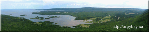
For those who may now be confused Aspy Bay is both a community in the above valley and the body of water on the far left of the picture. This site is devoted to promoting the community of Aspy Bay and all communities in the valley.
The Aspy Bay Valley contains three rivers (North, Middle and South Aspy River) flowing into three harbours (North, Middle and South Harbour) mostly blocked from the ocean by over 10 miles of white sandy beach. Featured above is a clear view of the North Aspy River emptying into North Harbour. The area is ideal for kayaking and canoeing. The harbours and rivers provide family safe conditions and the Atlantic Ocean is right there for the highly skilled water adventurer.
For history on the area a visit to the North Highlands Museum located in Cape North is a must. Make sure you visit them either online or better yet in person.
|
